Dasymetric Cartography Research Team
DACART is a
researcdh unit of the GeoTREE Center at the Department of Geography,
University of Northern Iowa.
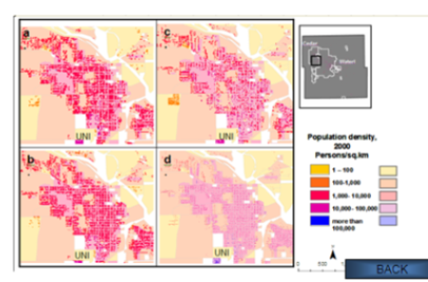
The purpose of DACART is to advance methods and applications of dasymetric mapping - a thematic cartography technique that allows using underlying ancillary data to enhance population distribution and density maps.
Dasymetric mapping gives high precision population maps that can be used for urban planning, disaster management, transportation, emergency response and other purposes.
Dasymetric Cartography Research Team
DACART is a
researcdh unit of the GeoTREE Center at the Department of Geography,
University of Northern Iowa.
The purpose of DACART is to advance methods and applications of dasymetric mapping - a thematic cartography technique that allows using underlying ancillary data to enhance population distribution and density maps.
Dasymetric mapping gives high precision population maps that can be used for urban planning, disaster management, transportation, emergency response and other purposes.
Andrey N. Petrov, PhD
Assistant ProfessorDr. Petrov studies methods and applications of dasytetric mapping in urban environemnts. He is particurlarly interested in use of high resolution remotely sensed data and LiDAR data in developing dasymetric maps of complex urban environemnts. He is also published on history of dasymetric mapping.
Philip A. Cavin
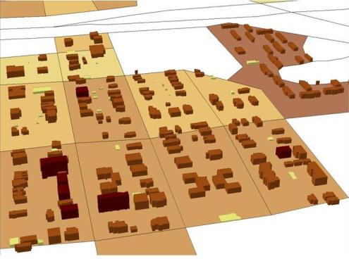
Graduate StudentPhilip conducts comparative analysis of dasytetric mapping techniques, specifically focusing on 3D intelligent dasymetric mapping using airborne LiDAR data. He contributed to the development of floor-fraction and volume-fractions methods.

Robert J. Stephens
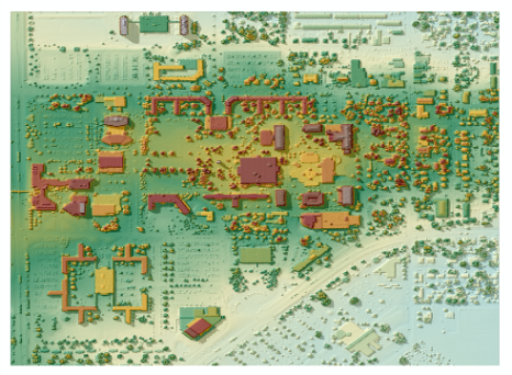
Graduate StudentRobert works with LiDAR data to enhance 3D dasymetric mapping technology. He is also working with LiDAR to develop an automated algorythm for extracting building footprints for dasymetric maps and other uses.
DACART projects